Updates:
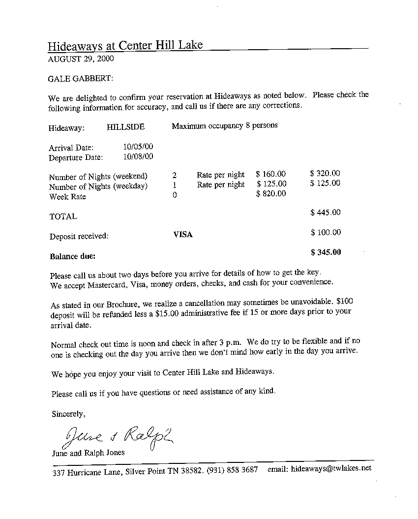
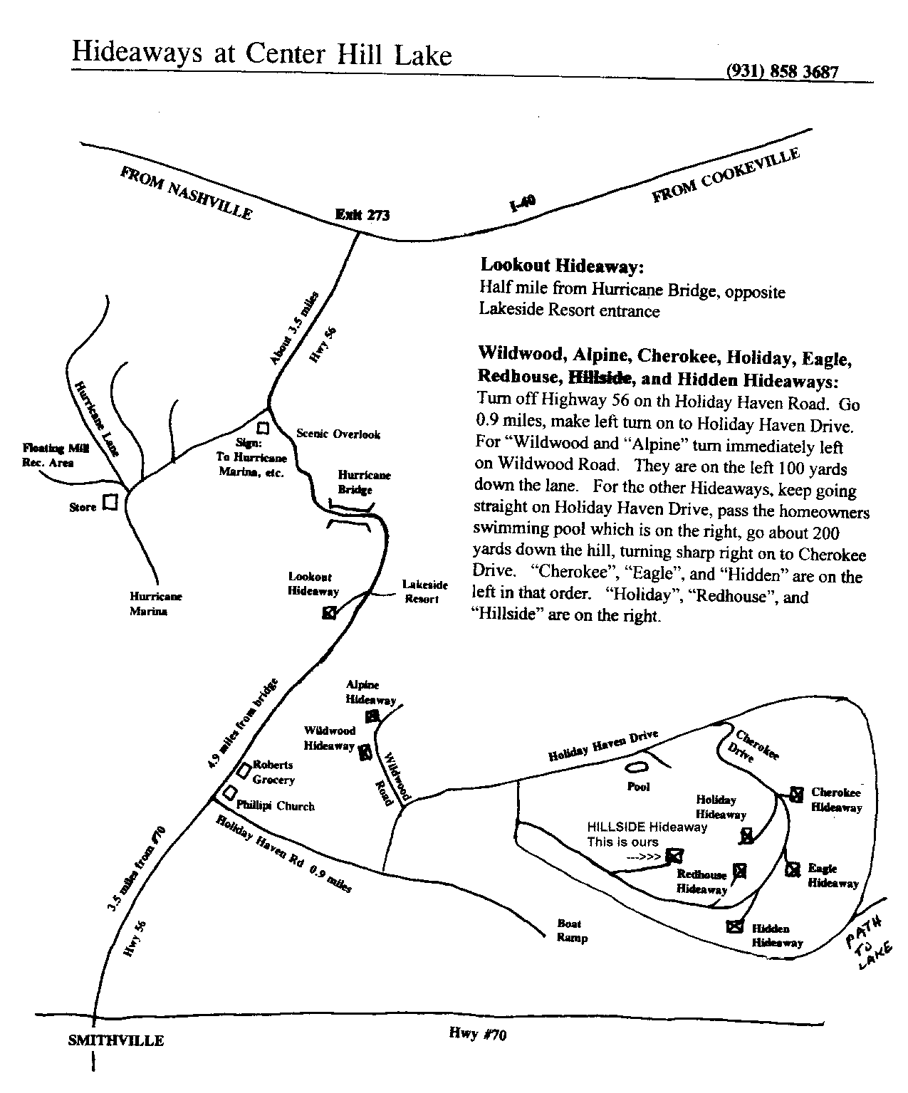
The houseboat is located at the Edgar Evins marina on Center Hill Lake, in Edgar Evins State Park, Silver Point, Tennessee.
MapQuest can provide driving directions to Silver Point, TN, from Vicksburg, MS (520 miles) and from Evanston, IL (548 miles). Both routes end up on heading east on Interstate 40; remember to use exit 268 onto highway 96 [south] after Carthage, but before Cookeville. You can also view a local map at the houseboat site.
Some other Web resources related to the trip:
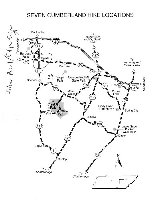
These are hikes that (a) did not seem too far from either the lake or the route there and back, and (b) sounded somewhat interesting. In most cases, the descriptions don't mention whether dogs are allowed or not.
Numbers are from the book Hiking Tennessee, by Kelley Roark (ISBN 1-56044-394-4) which can be ordered from Adventurous Traveler, # G4445.
Long Hunter State Recreation Park covers more than 2,400 acres along the east side of 14,000-acre J. Percy Priest Lake. The lake itself was created in 1968 by the U.S. Army Corps of Engineers by impounding the Stones River for flood control and hydroelectricity. the park was created in 1972 when the area was leased by the Corps of Engineers to the Tennessee Wildlife Resources Agency.
General description: This trail is the most popular of the park's
trails, and it offers scenic views of the 110-acre Couchville Lake as it
follows the shore.
Length: 2 miles.
Degree of difficulty: Easy (ought to be, with the name "COUCHville")
Elevations: Start and end 500 feet.
Map: USGS quad 31SE, La Vergne.
-- Recommendation: Boring
At 831 acres, Cedars of Lebanon State Park includes the largest eastern red-cedar forest remaining in the United States. It is bordered by the 8,056-acre Cedars of Lebabnon State Forest and Natural Area, which is managed by the Department of Agriculture, Division of Forestry. The park is also one of the recreational areas along the Trail of Tears State Scenic Route.
This area was badly abused by farmers prior to the 1930s, with the forest heavily cut (primarily for pencils), burned, and damaged by overgrazing. The U.S. Department of Agriculture established a reforestation project in the area in 1936 and replanted 792,000 Eastern red cedars to control erosion and restore the forest. The area was developed as a state park and forest, and in 1955 the federally managed land was deeded to the state.
The area is interesting ecologically and geologically because it contains cedar glades, also known as limestone glades, which are a companion to cedar forests and support a wide variety of plants and animals. Cedar glades are dry rocky barrens between stands of cedar, that host a variety of plants that do not survive elsewhere in the area. There are nineteen species of plants endemic to the cedar glades of Middle Tennessee, and seventeen of these can be found in the park, including the Tennessee purple coneflower, which is on the federal endangered species list. The limestone concentrations here create geologic features known as "karst" topography, after the Karst region in Yugoslavia, which exhibits similar formations. Karst formations include caves, sinkholes, and disappearing streams all created over millions of years from water running through and eroding porous limestone.
General description: This loop trail provides an opportunity to explore
cedar glades, examine limestone formations, and enjoy the great variety
of rare wildflowers, plants, and trees found in the karst region.
Length: 8 mile loop.
Level of difficulty: Easy
Elevation: Start and end 680 feet; change 80 feet.
Map: USGS quad 314SE, Vine.
-- Recommendation: Long. Geological and ecological interest, if we have
time.
General description: This short nature trail provides a brief
introduction to karst topography and leads through cedar glades.
Length: 0.5 mile
Degree of difficulty: Easy
Map: USGS quad 314SE, Vine
-- Recommendation: Too short, but might be geologically and ecologically
interesting
The Old Stone Fort State Archeological Area encompasses nearly 800 acres of land in Manchester. Its focus is a Middle Woodland Period Indian ceremonial enclosure located on a plateau between the Bark Camp Fork and Barren Fork of the Duck River. The site is a wall mound hilltop enclosure begun nearly 2,000 years ago during the first Indian mound-building period. The entryway to the enclosure lines up within a half-degree of the sunrise of the summer solstice, suggesting that planting and fertility ceremonies may have been performed here. This ceremonial ground is believed to have been used by early Indians for more than 500 years. A museum at the wall entrance has exhibits of Woodland culture, film presentations, and artifact demonstrations.
General Description: This trail follows the circumference of the wall
mound around this ancient ceremonial place, dating from the Woodland
Period, and passes the highlights of the archeological area.
Length: 1.25 miles
Degree of difficulty: Easy
Map: USGS quad 86NE, Manchester.
-- Recommendation: Historical interest
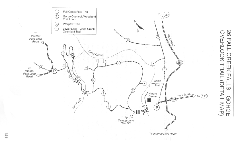
General Description: These trails combined create a well-travelled
loop trail that leads to Fall Creek Falls and passes several dramatic
overlooks along the way.
Length: 1.2 miles, plus 0.5 each way to base of the falls.
Degree of difficulty: Easy; difficult on trail to base of falls.
Map: USGS quad 103NE, Sampson
-- Recommendation: Short, with nice waterfall
Picture of Fall Creek Falls
General Description: This overnight trail follows the rim of Cane
Creek Gulf, passes over three suspension bridges, and provides numerous
spectacular vistas of the most scenic section of the park.
Length: 13 miles
Degree of difficulty: Difficult
Map: USGS quads 103NW, Spencer; 103NE, Sampson.
-- Recommendation: Too long
Ozone Falls State Natural Area is probably the state's smallest natural area, but has a graceful 100-foot waterfall as beautiful as any, less than 0.5 mile walk from the roadside. Located near the small town of Ozone (not), the natural area was created to protect the falls, which were called McNair Falls and Mammy Falls, after nearby Mammy Creek, until 1896 when they were renamed Ozone Falls because of "the stimulating quality of the air" at the falls.
Ozone Falls also has an accessible sheer rock face that is excellent for honing rock climbing skills. The top of the cliff is at the edge of the parking area, and the short, 0.25-mile hike to the base of the falls makes an easy return to the top if you are interested in rappelling (real climbers say "abseiling") down a dramatic distance, but not in climbing back up the way you came.
General description: This is one of the most accessible short hikes to a
dramatic falls in Tennessee, with a moderately steep path down to the
base of the 100-foot Ozone Falls.
Length: 0.25 mile
Degree of difficulty: Moderate
Elevation: Start 1,570 feet; end 1,460 feet.
Map: USGS quad 117NE, Ozone
-- Recommendation: Yes. "Although there is not much to this short hike,
it does have a spectacular reward for a small amount of effort." Also,
it's on the way.
Picture of Ozone Falls.
Finding the trailhead: Take U.S. Highway 70 east from Nashville, or west from Knoxville, to the small town of Ozone, between Crossville and Rockwood.
General description: This level trail crosses a small footbridge and
circles Byrd Lake along the shore, following one of its feeder streams
before crossing it and returning along the other side of the lake.
Length: 5 miles; short loop 2 miles
Degree of difficulty: Easy
Elevations: Start and end 1,750; change 50 feet.
Connections: Byrd Lake Trail.
Map: USGS quad 109NE, Crossville.
The following descriptions are from Middle Tennessee on Foot: Hikes in the Woods & Walks on Country Roads [1998], by Robert Brandt (ISBN 0-89587-212-9), also available from Adventurous Traveler, # G11943.
The excellent trail network that winds through the archaeological site and above the tumbling streams offers some of the finest walking in Middle Tennessee. There's an easy walk of 1.25 miles around the wall, but it misses some of the most spectacular scenery. The hike described below combines part of the wall walk with more remote trails. The park's location within the city of Manchester makes its dogwood-lined roads popular with walkers, too.
Edgar Evins State Park provides an opportunity to enjoy 6,000 acres of shoreline, steep hills, and deep hollows. Its rich second-growth forest is a good place to look for spring and summer wildflowers and to enjoy brilliant fall foliage. There is only one hiking trail at Edgar Evins, but more are planned.
The late Joe L. Evins from nearby Smithville represented the Upper Cumberland in Congress from 1946 to 1976. Incidentally, he was preceded by Albert Gore and succeeded by Albert Gore, Jr., both of whom have homes on the Caney Fork downstream from Center Hill Dam. Evins used his position as chairman of the House Appropriations Subcommittee on Public Works to get the Corps of Engineers to set aside land for the park, which opened in the 1970s. It's named for his father.
Like so many Middle Tennessee settlers, Tom Burgess settled on a grant given for his Revolutionary War service. This spot, located where the narrow gorge squeezes the river, was ideal for a mill. The Burgess family started both a sawmill and a gristmill in the early 1800s.
In 1924, the city of Cookeville built a dam on the river to generate electricity. A flood washed it away in 1928. It was replaced by the concrete-and-steel dam you see today. The arrival of TVA electricity in the 1940s rendered the dam obsolete, but the people of Cookeville had the wisdom to preserve the area for outdoor recreation and wildlife conservation. A cooperative-management arrangement with the state led to the recognition of Burgess Falls as a state natural area in 1980.
Picture of Burgess Falls.
Couchville is on a lake just east of Nashville.
Burgess Falls is about eight miles south-southwest of I-40 on TN-135, past Samaria, Ditty, Boiling Springs, and Hillrose. The intersection between I-40 and TN-135 is southwest of Cookeville. TN-135 is about 12.2 miles from Silver Point, along I-40.
This is confusing: the "Precision Mapping" CD-ROM says Ozone, Tennessee is north of I-40, about halfway between I-40 and the Kentucky border, but the hiking book and the topo map both insist there's an Ozone south of I-40, between Crab Orchard (east of Crossville) and Knoxville. (Considering that crabs don't grow on trees, would you believe there are no fewer than six towns called "Crab Orchard" in the US? Illinois, Kentucky, Nebraska, Tennessee, Virginia, and West Virginia, as well as Crab Orchard Estates, Illinois. Since all of these except Virginia are land-locked, maybe they don't know from crabs. Or maybe someone brought crabs west through all these states.)
Crab Orchard is just west of Ozone, and appears to be more than 100 miles east of Nashville. We could get from Silver Point to Ozone either along I-40 or US-70. I assume US-70 is slower than I-40, but it might also be more scenic. The topo map shows some lovely quarries and strip mines in the area, though some of them are probably not visible from either highway. There's also a Hatfield Gap and Hatfield Mountain about 6-7 miles north of Ozone, but I don't see any McCoys.
If you travel east on I-40 from Nashville, you pass through Cookeville, then Crossville before reaching Crab Orchard and Ozone. If you travel east on US-70 instead, you pass through Sparta and Pleasant Hill before Crossville. It looks as if one could turn south from I-40 onto TN-111 in Cookeville in order to get to US-70, a distance of about 14.6 miles. Note that US-70N is quite different from 70.
The highways in the area of the lake are confusing me, too. 136 goes south from Cookeville, and apparently turns into 164. 111 crosses 70 farther west, but then also converges with 164. US Highway 70 is also sometimes known as State Highway 26.
The distance along I-40 from Silver Point to the intersection with 136 appears to be about 13.8 miles.
Silver Point is just about at the intersection of I-40 and SH-56. SH-56 goes south from Silver Point, then intersects with US-70 in Smithville. The distance along SH-56 from Silver Point to US-70 (Smithville) would be about 12 miles if it were more nearly a straight line, with 56 emphatically is not.
To go from Silver Point to Fall Creek Falls, we could either take SH-56 to highway 70 to Sparta, then south on 111; or I-40 west to Cookeville, then south on 111 through Sparta. I think the I-40 route would probably be faster. From Silver Point to 136/164 along I-40 is about 13.6 miles. From I-40 south to US-70 (Sparta) is about 14.9 miles. We would travel south from either I-40 or US-70 to Spencer, where 111 joins 30. We could then either continue straight south on 111 or turn east on 30. Fall Creek Falls State Park seems to be in between the two. From Sparta to Spencer is about 13.0 miles. From Spencer to 284 along 111 is about 8.3 miles. The entrance to the park is about 7.3 miles along 284. The other way, along 30, is about 11 miles from Spencer.
I'd rather come into the park from 284. (See map.) From the parking area, we could either take hike 3, or (preferably) stop at the Nature Center, then cross the bridge to hike 2, either the long loop to the northwest or the shorter 4/2 route west, then cross the two bridges to see the falls. If we wanted to minimize the walking, we could come in from highway 30 on the east and take the short route to the falls.